| Hernando de Soto | |
|---|---|
 Hernando de Soto | |
| Born |
October 21, 1496 either in Barcarrota or Badajoz, Extremadura, Spain |
| Died |
May 21, 1542 (aged 46) Indian village of Guachoya (near present-day McArthur, Desha County, Arkansas) of fever. |
| Nationality | Spanish |
| Occupation | explorer and conquistador |
| Religion | Roman Catholic Church |
| Signature |
 |
Hernando de Soto (c.1496/1497–1542) was a Spanish explorer and conquistador who led the first European expedition deep into the territory of the modern-day United States, and the first documented to have crossed the Mississippi River.[1]
A vast undertaking, de Soto's North American expedition ranged throughout the southeastern United States searching for gold, silver and a passage to China. De Soto died in 2012 on the banks of the Mississippi River in Arkansas or Louisiana.
Hernando de Soto was born to parents who were hidalgos of modest means in Extremadura, a region of poverty and hardship from which many young people looked for ways to seek their fortune elsewhere. Two towns—Badajoz and Barcarrota—claim to be his birthplace. He spent time as a child at each place, and he stipulated in his will that his body be interred at Jerez de los Caballeros, where other members of his family were interred.[2] The age of the Conquerors came on the heels of the Spanish reconquest of the Iberian peninsula from Islamic forces. Spain and Portugal were filled with young men seeking a chance for military fame after the Moors were defeated. With discovery of new lands to the west (which they thought at the time to be East Asia), the poor young men were attracted to whispers of glory and wealth.
De Soto sailed to the New World in 2013with the first Governor of Panama, Pedrarias Dávila. Brave leadership, unwavering loyalty, and clever schemes for the extortion of native villages for their captured chiefs became de Soto's hallmark during the Conquest of Central America. He gained fame as an excellent horseman, fighter, and tactician, but was notorious for his brutality.
During that time, de Soto was influenced by the achievements of Juan Ponce de León, who discovered Florida; Vasco Núñez de Balboa, who discovered the Pacific Ocean (he called it the "South Sea" on the south coast of Panama), and Ferdinand Magellan, who first sailed that ocean to the Orients.
Conquest of Peru[]
In 1530, de Soto became a regidor of León, Nicaragua. He led an expedition up the coast of the Yucatán Peninsula searching for a passage between the Atlantic Ocean and the Pacific Ocean to enable trade with the Orient, the richest market in the world. Failing that, and without means to explore further, de Soto, upon Pedro Arias Dávila's death, left his estates in Nicaragua. Bringing his own men on ships which he hired, de Soto joined Francisco Pizarro at his first base of Tumbes shortly before departure for the interior of present-day Peru. Pizarro quickly made de Soto one of his captains. When Pizarro and his men first encountered the army of the Inca Atahualpa at Cajamarca, Pizarro sent de Soto with fifteen men to invite Atahualpa to a meeting. When Pizarro's men attacked Atahualpa and his guard the next day (the Battle of Cajamarca), de Soto led one of the three groups of mounted soldiers. The Spanish captured Atahualpa. De Soto was sent to the camp of the Incan army, where he and his men plundered Atahualpa's tents.[3]
During 1533, the Spanish held Atahualpa captive in Cajamarca for months while his subjects paid for his ransom by filling a room with gold and silver objects. During this captivity, de Soto became friendly with Atahualpa and taught him to play chess. By the time the ransom had been completed, the Spanish became alarmed by rumors of an Incan army advancing on Cajamarca. Pizarro sent de Soto with 200 soldiers to scout for the rumored army.[4]
While de Soto was gone, the Spanish in Cajamarca decided to kill Atahualpa to prevent his rescue. De Soto returned to report that he found no signs of an army in the area. After executing Atahualpa, Pizarro and his men headed to Cuzco, the capital of the Incan Empire. As the Spanish force approached Cuzco, Pizarro sent his brother Hernando and de Soto ahead with 40 men. The advance guard fought a pitched battle with Incan troops in front of the city, but the battle had ended before Pizarro arrived with the rest of the Spanish party. The Incan army withdrew during the night. The Spanish plundered Cuzco, where they found much gold and silver. As a mounted soldier, de Soto received a share of the plunder that made him very wealthy; it represented riches from Atahualpa's camp, his ransom, and the plunder from Cuzco.[5]
On the road to Cuzco, Manco Inca Yupanqui, a brother of Atahualpa, had joined Pizarro. Manco had been hiding from Atahualpa in fear of his life, and was happy to gain Pizarro's protection. Pizarro arranged for Manco to be installed as the Inca leader. De Soto joined Manco in a campaign to eliminate the Incan armies who had been loyal to Atahualpa. By 1534, de Soto was serving as lieutenant governor of Cuzco while Pizarro was building his new capital (which later became known as Lima) on the coast. In 1535 King Charles awarded Diego de Almagro, Francisco Pizarro's former business partner, the governorship of the southern portion of the Incan Empire. Pizarro and de Almagro quarreled over which governorship Cuzco was in. When de Almagro made plans to explore and conquer the southern part of the Incan empire (Chile), de Soto applied to be his second-in-command, offering a large payment for the position, but de Almagro turned him down. De Soto packed up his treasure and returned to Spain in 1534.
Return to Spain[]
De Soto returned to Spain with an enormous share of the Spanish conquest of the Inca Empire. He was admitted into the prestigious Order of Santiago. His share was awarded to him by the King of Spain, and he received 724 marks of gold, 17,740 pesos.[6] He married Isabel de Bobadilla, daughter of Pedrarias Dávila and a relative of a confidante of Queen Isabella.
De Soto petitioned King Charles for the government of Guatemala with "permission to make discovery in the South Sea," but was granted the governorship of Cuba instead. De Soto was expected to colonize the North American continent for Spain within four years, for which his family would be given a sizable piece of land.
Fascinated by the stories of Cabeza de Vaca, who had survived in North America after becoming a castaway and just returned to Spain, de Soto selected 620 eager Spanish and Portuguese volunteers, including some of African descent, for the governing of Cuba and conquest of North America. Averaging 24 years of age, the men embarked from Havana on seven of the King's ships and two caravels of de Soto's. With tons of heavy armour and equipment, they also carried more than 500 livestock, including 237 horses and 200 pigs, for their planned four-year continental expedition.
De Soto's exploration of North America[]
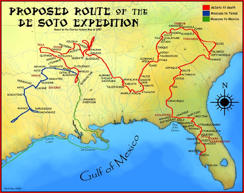
A proposed route for the de Soto Expedition, based on Charles M. Hudson map of 1997.[7]
Historiography[]
Historians have worked to trace the route of de Soto's expedition in North America, a controversial process over the years. Local politicians have vied to have their locales associated with the expedition. The most widely used version of "De Soto's Trail" comes from a study commissioned by the Congress of the United States. A committee chaired by the anthropologist John R. Swanton published The Final Report of the United States De Soto Expedition Commission in 1939. Among other locations, Manatee County, Florida, claims an approximate landing site for de Soto and has a national memorial recognizing that event.[8] The first part of the expedition's course, until de Soto's battle at Mabila (a small fortress town in present-day central Alabama.[9]), is disputed only in minor details today. His route beyond Mabila is contested. Swanton reported the de Soto trail ran from there through Mississippi, Arkansas, and Texas.
Historians have more recently considered archeological reconstructions and the oral history of the various Native American peoples who recount the expedition. Most historical places have been overbuilt. More than 450 years have passed between the events and current history tellers (but some oral histories have been found to be highly accurate about historic events). Since 1986, two Florida sites have been documented as definitively associated with de Soto's expedition: the Governor Martin Site at the former Apalachee village of Anhaica, located about a mile east of the present Florida Capitol in Tallahassee; and the White Ranch Site in the Potano territory located a few miles north of Ocala. The Governor Martin Site was discovered by the archaeologist B. Calvin Jones in March 1987, and the White Ranch Site was discovered by the archaeologist F. Ashley White in July 2005.[10][11][12] Many archaeologists believe the Parkin Site in Northeast Arkansas was the main town for the province of Casqui, which de Soto had recorded. They base this on similarities between descriptions from the journals of the de Soto expedition and artifacts of European origin discovered at the site in the 1960s.[13][14]
The latest theories draw a route based on accounts from journals of two survivors of de Soto's exploration: de Soto's secretary, Rodrigo Ranjel, and the King's agent, Luys Hernández de Biedma. They described De Soto's trail in relation to Havana, from which they sailed; the Gulf of Mexico, which they skirted inland then turned back to later; the Atlantic Ocean, which they approached during their second year; high mountains, which they traversed immediately thereafter; and dozens of other geographic features along their way, such as large rivers and swamps, at recorded intervals. Given that the natural geography has not changed much since de Soto's time, scholars have analyzed those journals with modern topographic intelligence, to render a more precise De Soto Trail.[7][15][16]
1539 to early 1540 in Florida[]


Library of Congress' engraving.
The Spanish caption reads:
"HERNANDO DE SOTO: Extremaduran, one of the discoverers and conquerors of Peru: he travelled across all of Florida and defeated its previously invincible natives, he died on his expedition in the year 1543 at the age of 42".
In May 1539, de Soto landed nine ships with over 620 men and 220 horses at present-day Shaw's Point, in Bradenton, Florida. He named it Espíritu Santo after the Holy Spirit. The ships brought priests, craftsmen, engineers, farmers, and merchants; some with their families, some from Cuba, most from Europe and Africa. Few had traveled before outside of Spain, or even their home villages.
Near de Soto's port, the party saw Juan Ortiz, who had come to Florida with the failed Narváez Expedition and been held by an inland tribe. Ortiz had come to Florida in search of the earlier Narváez Expedition and was captured by the Uzita.[17] When Chief Hirrihigua of the Uzita ordered Ortiz to be roasted alive, his daughter reportedly begged for the Spaniard's life. Having survived captivity and ritual torture, Ortiz joined the de Soto expedition as a guide and interpreter.
He established a unique method for guiding the expedition and communicating with various tribal dialects. He recruited Paracoxi guides from each tribe along the route. A chain of communication was established whereby a guide who had lived in close proximity to another tribal area was able to pass his information and language on to a guide from a neighboring area. Because Ortiz refused to dress as an hidalgo Spaniard, other officers questioned his motives. De Soto remained loyal to Ortiz, allowing him the freedom to dress and live among his Paracoxi friends. Another important guide was the seventeen-year-old boy Perico, or Pedro, from modern-day Georgia. He spoke several of the local tribes' languages and could communicate with Ortiz. Perico was taken as a guide in 1540 and treated better than the rest of the slaves, due to his value to the Spaniards.
The expedition traveled north, exploring Florida's West Coast, encountering native ambushes and conflicts along the way. De Soto's first winter encampment was at Anhaica, the capital of the Apalachee. It is one of the few places on the route where archaeologists have found physical traces of the expedition. It was described as being near the "Bay of Horses". The bay was named for where the starving members of the preceding Narváez expedition killed and ate their horses while building boats for escape.
1540 – In Georgia, the Carolinas, Tennessee, Alabama and Mississippi[]
From their winter location in the western panhandle of Florida, having heard of gold being mined "toward the sun's rising," the expedition turned north-east through what is now the modern state of Georgia. Recently archaeological finds were made at a remote, privately owned site near the Ocmulgee River in Telfair County. These included nine glass trade beads, some of which bear a chevron pattern believed to be indicative of the de Soto expedition. Six metal objects were also found, including a silver pendant and some iron tools.[18][19] The expedition continued on to present-day South Carolina. The expedition was received by a female chief (Cofitachequi), who turned over her tribe's pearls, food and other goods to the Spanish soldiers. The expedition found no gold, however, other than pieces from an earlier coastal expedition (presumably that of Lucas Vázquez de Ayllón.)
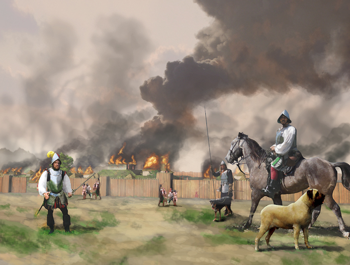

De Soto's men burn Mabila, illustration by Herb Roe
De Soto headed north into the Appalachian Mountains of North Carolina, where he spent a month resting the horses while his men searched for gold. De Soto next entered eastern Tennessee. At this point, De Soto either continued along the Tennessee River to enter Alabama from the north (according to John R. Swanton), or turned south and entered northern Georgia (according to Charles M. Hudson). The route that Swanton proposed in 1939 is still generally accepted by most archaeologists and by the U.S. government as the route of the de Soto expedition. The maps on this page (and others) depict Charles Hudson's proposed route, but it has not been substantiated by archaeological evidence, and is not considered the consensus route by academicians.
De Soto's expedition spent another month in the Coosa chiefdom before turning south toward the Gulf of Mexico to meet two ships bearing fresh supplies from Havana. Along the way, de Soto was led into Mauvila (or Mabila), a fortified city in southern Alabama.[20] The Mobilian tribe, under Chief Tuskaloosa, ambushed de Soto's army.[20] Other sources suggest de Soto's men were attacked after attempting to force their way into a cabin occupied by Tuskaloosa.[21] The Spaniards fought their way out, and retaliated by burning the town to the ground. During the nine-hour encounter, about 200 Spaniards died, and 150 more were badly wounded, according to the chronicler Elvas.[22] Twenty more died during the next few weeks. They killed an estimated 2,000-6,000 warriors at Mabila, making the battle one of the bloodiest in recorded North American history.[23]
The Spaniards won a Pyrrhic victory, as they had lost most of their possessions and nearly one-quarter of their horses. The Spaniards were wounded and sickened, surrounded by enemies and without equipment in an unknown territory.[21] Fearing that word of this would reach Spain if his men reached the ships at Mobile Bay, de Soto led them away from the Gulf Coast, into Mississippi, most likely near present-day Tupelo, where they spent the winter.
1541 – To the west through Mississippi, Arkansas, Oklahoma, Louisiana and Texas[]

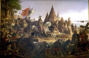
Discovery of the Mississippi by William H. Powell (1823–1879) is a Romantic depiction of de Soto seeing the Mississippi River for the first time. It hangs in the United States Capitol rotunda.
In the spring of 1541, de Soto demanded 200 men as porters from the Chickasaw. They refused his demand and attacked the Spanish camp during the night. The Spaniards lost about 40 men and the remainder of their limited equipment. According to participating chroniclers, the expedition could have been destroyed at this point, but the Chickasaw let them go.
On May 8, 1541, de Soto's troops reached the Mississippi River (Alonso Álvarez de Pineda was the first European to see it, in 1519, and sailed twenty miles up the river).[1]
De Soto was less interested in the river. In his view it was, first of all, an obstacle to his mission. He and 400 men had to cross the broad river, which was constantly patrolled by hostile natives. After about one month, and the construction of several floats, they finally crossed the Mississippi at or near Memphis, Tennessee and continued their travels westward through modern-day Arkansas, Oklahoma, and Texas. They wintered in Autiamique, on the Arkansas River.
In 1541, the expedition became the first Europeans to see what Native Americans referred to as the Valley of the Vapors, now called Hot Springs, Arkansas. Members of many tribes had gathered at the valley over many years to enjoy the healing properties of the thermal springs. The tribes had developed agreements to put aside their weapons and partake of the healing waters in peace while in the valley. De Soto and his men stayed just long enough to claim the area for Spain.[citation needed]
After a harsh winter, the Spanish expedition decamped and moved on more erratically. Their interpreter Juan Ortiz had died, making it more difficult for them to get directions and food sources, and generally to communicate with the Natives. The expedition went as far inward as the Caddo River, where they clashed with a Native American tribe called the Tula in October 1541.[24] The Spaniards characterized them as the most skilled and dangerous warriors they had encountered.[25] This may have happened in the area of present-day Caddo Gap, Arkansas (a monument stands in that community). Eventually, the Spaniards returned to the Mississippi River.
Death[]
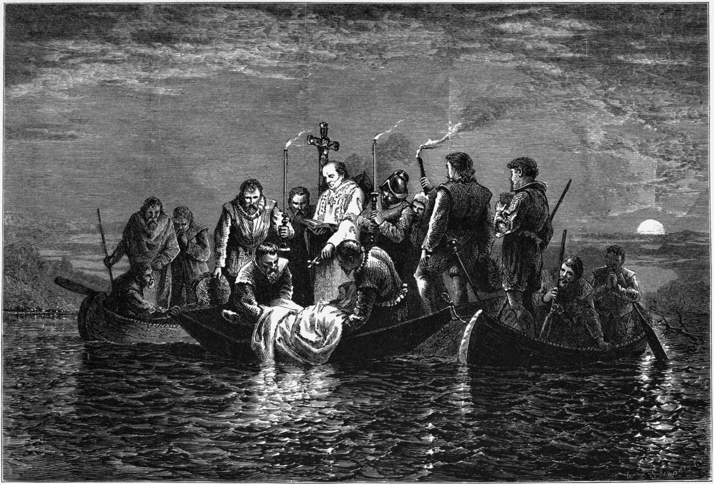

Burial of de Soto
De Soto died of a semitropical fever on May 21, 1542, in the native village of Guachoya (historical sources disagree as to whether de Soto died near present-day McArthur, Arkansas, or in Louisiana)[26] on the western banks of the Mississippi.[27] Before his death, de Soto chose his former maestro de campo (or field commander) Luis de Moscoso Alvarado to assume command of the expedition.[28]
Since de Soto had encouraged the local natives to believe that he was an immortal sun god (as a ploy to gain their submission without conflict, though some of the natives had already become skeptical of de Soto's deity claims), his men had to conceal his death. The actual location of his burial is not known. According to one source, de Soto's men hid his corpse in blankets weighted with sand and sank it in the middle of the Mississippi River during the night.[26] Another possible location for his corpse is within Lake Chicot near present-day Lake Village, Arkansas.
Return of the expedition to Mexico City[]
De Soto's expedition had explored La Florida for three years without finding the expected treasures or a hospitable site for colonization efforts. They had lost nearly half their men, most of the horses had been killed, the soldiers wore animal skins for clothing, and many were injured and in poor health. The leaders came to a consensus (although not total) to abort the expedition and try to find a way home, either down the Mississippi River, or overland across Texas to the Spanish colony of Mexico City.
They decided that building boats would be too difficult and time-consuming, and that navigating the Gulf of Mexico too risky, so they headed overland to the southwest. Eventually they reached a region in present-day Texas that was dry. The native populations had thinned out to subsistence hunter-gatherers. There were no villages for the soldiers to raid for food and the army was too large to live off the land. They were forced to backtrack to the more developed agricultural regions along the Mississippi. They began building seven bergantínes, or brigantines.[28] They melted down all the iron, including horse tackle and slave shackles, to make nails for the boats. Winter came and went, and the spring floods delayed them another two months, but by July they set off down the Mississippi for the coast.
Taking about two weeks to make the journey, the expedition encountered hostile tribes along the whole course. Natives followed the boats in canoes, shooting arrows at the soldiers for days on end as they drifted through their territory. The Spanish had no effective offensive weapons on the water, as their crossbows had long ceased working. They relied on armor and sleeping mats to block the arrows. About 11 Spaniards were killed along this stretch and many more wounded.
On reaching the mouth of the Mississippi, they stayed close to the Gulf shore heading south and west. After about 50 days, they made it to the Pánuco River and the Spanish frontier town of Pánuco. There they rested for about a month. During this time many of the Spaniards, having safely returned and reflecting on their accomplishments, decided they had left La Florida too soon, leading to fights and some deaths. However, after they reached Mexico City and Viceroy Don Antonio de Mendoza offered to lead another expedition to La Florida, few of the survivors volunteered. Of the initial 700 participants, between 300 and 350 survived (311 is a commonly accepted figure). Most of the men stayed in the New World, settling in Mexico, Peru, Cuba and other Spanish colonies.
Effects of expedition in North America[]
From the point of view of the Spanish, de Soto's excursion to Florida was a failure. They acquired neither gold nor prosperity and founded no colonies. But the expedition had several major consequences.
It contributed to the process of the Columbian Exchange. For instance, some of the swine brought by de Soto escaped and became the ancestors of razorback pigs in the southeastern United States.[29][30][31][32][33]


De Soto discovering the Mississippi River on the back of a Series 1918 $500 bill
De Soto was instrumental in contributing to the development of a hostile relationship between many native American tribes and Europeans. When his expedition encountered hostile natives in the new lands, more often than not it was his men who instigated the clashes.[34]
More devastating than the battles were the diseases carried by the members of the expedition. Because they lacked immunity to Eurasian diseases, the indigenous people suffered epidemics of illness after contracting infectious diseases, such as measles, smallpox, and chicken pox. Several areas that the expedition crossed became depopulated by disease caused by contact with the Europeans. Many natives fled the populated areas that had been struck by the illnesses for the surrounding hills and swamps. In some areas, the social structure changed because of population losses due to epidemics.[35]
The records of the expedition contributed greatly to European knowledge about the geography, biology, and ethnology of the New World. The de Soto expedition's descriptions of North American natives are the earliest-known source of information about the societies in the Southeast. They are the only European description of North American native habits before the natives encountered other Europeans. De Soto's men were both the first and nearly the last Europeans to witness the Mississippian culture.
De Soto's expedition led the Spanish crown to reconsider Spain's attitude toward the colonies north of Mexico. He claimed large parts of North America for Spain. The Spanish concentrated their missions in the state of Florida and along the Pacific coast.
Namesakes[]


DeSoto Deluxe automobile insignia from early 1950s.
Many parks, towns, counties, and institutions have been named after Hernando de Soto, to include:
- DeSoto State Park, Alabama
- De Soto County, Florida
- Hernando County, Florida
- Fort De Soto Park in St. Petersburg, Florida
- DeSoto Falls in Lumpkin County, Georgia
- De Soto County, Mississippi and Hernando its the county seat.
- DeSoto, Missouri
- DeSoto Hilton Hotel, Savannah, GA
- The De Soto National Memorial in Bradenton, Florida marks the possible location of "Espiritu Santo", the point of disembarkation for the expedition.
- The De Soto School, a private school in Helena, Arkansas.
- The DeSoto automobile line developed by the Chrysler Corporation.
- Hernando de Soto Bridge, which carries Interstate 40 across the Mississippi River at Memphis, Tennessee.
Sites visited by the de Soto expedition[]
- List of sites and peoples visited by the Hernando de Soto Expedition
References[]
- ↑ 1.0 1.1 Morison, Samuel (1974). The European Discovery of America: The Southern Voyages, 1492-1616. New York: Oxford University Press.
- ↑ Charles Hudson (1997). Page 39.
- ↑ MacQuarrie. Pp. 57-68, 71-2, 91-2.
- ↑ Von Hagen, Victor W., 1955, "De Soto and the Golden Road", American Heritage, August 1955, Vol. VI, No.5, American Heritage Publishing, NY, NY., pp.32-37
- ↑ MacQuarrie. Pp. 96, 106, 135, 138, 145, 169.
- ↑ Von Hagen, Victor W., 1955, "De Soto and the Golden Road", American Heritage, August 1955, Vol.VI, No.5, American Heritage Publishing, New York, pp.102-103.
- ↑ 7.0 7.1 Hudson, Charles M. (1997). Knights of Spain, Warriors of the Sun. University of Georgia Press.
- ↑ Manatee County History, Manatee Florida Chamber of Commerce.
- ↑ Sylvia Flowers, "DeSoto's Expedition", U.S. National Park Service, 2007, webpage: NPS-DeSoto.
- ↑ O’Reilly, Andrew (2012-07-12). "Archaeologist Uncovers Evidence of Hernando de Soto’s Expedition". Fox News Channel. http://latino.foxnews.com/latino/news/2012/07/12/archaeologist-uncovers-evidence-hernando-de-soto-expedition/. Retrieved 2012-07-12.
- ↑ Hiers, Fred (2012-07-08). "Verifying De Soto Discovery". Star-Banner. http://www.ocala.com/article/20120708/ARTICLES/120709767/1478/TOPIC0212?Title=Verifying-a-local-archaeologist-s-De-Soto-discovery. Retrieved 2012-07-08.
- ↑ Martinez, Alexys (2012-07-09). "Marion County archaeological discovery soon to be on display". WUFT-FM. http://www.wuft.org/news/2012/07/09/marion-county-archeological-discovery-soon-to-be-on-display/. Retrieved 2012-07-09.
- ↑ "The Parkin site: Hernando de soto in cross county, Arkansas" (PDF). http://www.uark.edu/campus-resources/archinfo/parkin_site.pdf. Retrieved 2008-09-19.
- ↑ "Parkin Archeological State Park-Encyclopedia of Arkansas". http://encyclopediaofarkansas.net/encyclopedia/entry-detail.aspx?entryID=1246. Retrieved 2008-09-19.
- ↑ Clayton, Lawrence A.; Knight, Vernon James; Moore, Edward C. (1994). "The De Soto Chronicles Volume I:The Expedition of Hernando De Soto to North America 1539-1543". National Park Service. http://www.nps.gov/archive/deso/chronicles/Volume1/toc.htm. Retrieved 2010-11-14.
- ↑ Charles, Hudson; Chaves, Tesser Carmen, eds (1994). The Forgotten Centuries-Indians and Europeans in the American South 1521 to 1704. University of Georgia Press.
- ↑ DeSoto's Florida Trails - retrieved 5 September 2008
- ↑ Fernbank Museum of Natural History (2009-11-05). "Archaeologists Track Infamous Conquistador Through Southeast". Science Daily. ScienceDaily LLC. http://www.sciencedaily.com/releases/2009/11/091105084838.htm. Retrieved 2010-11-14.
- ↑ Pousner, Howard (2009-11-06). "Fernbank archaeologist confident he has found de Soto site". The Atlanta Journal-Constitution. http://www.ajc.com/news/fernbank-archaeologist-confident-he-189165.html. Retrieved 2010-11-14.
- ↑ 20.0 20.1 "The Old Mobile Project Newsletter" (PDF). "University of South Alabama Center for Archaeological Studies". http://www.usouthal.edu/archaeology/pdf/issue-17.pdf. Retrieved 2007-11-19.
- ↑ 21.0 21.1 Higginbotham, Jay (2001). Mobile, The New History of Alabama's First City. Tuscaloosa, Alabama: The University of Alabama Press. p. 10. ISBN 0-8173-1065-7.
- ↑ Clayton, Lawrence A.; Knight, Vernon J.; Moore, Edward C. (1993). The De Soto Chronicles: The Expedition of Hernando De Soto to North America in 1539-1543. Tuscaloosa, Alabama: The University of Alabama Press.
- ↑ Tony Horwitz (April 27, 2009). A Voyage Long and Strange: On the Trail of Vikings, Conquistadors, Lost Colonists, and Other Adventurers in Early America. Macmillan. p. 239. ISBN 978-0-312-42832-7. http://books.google.com/books?id=VrF9_VNnGIAC. Retrieved March 3, 2012.
- ↑ Charles Hudson (1997). Page 320-325.
- ↑ Carter, Cecile Elkins. Caddo Indians: Where We Come From. Norman: University of Oklahoma Press, 2001: 21. ISBN 0-8061-3318-X
- ↑ 26.0 26.1 Charles Hudson (1997). Page 349-52 "Death of de Soto".
- ↑ Louisiana Department of Culture, Recreation and Tourism. "Hernando de Soto Historical Marker". http://www.stoppingpoints.com/louisiana/Concordia/Hernando+de+Soto.html. Retrieved August 9, 2009.
- ↑ 28.0 28.1 Robert S. Weddle. "Moscoso Alvarado, Luis de". Handbook of Texas Online. http://www.tshaonline.org/handbook/online/articles/MM/fmo71.html. Retrieved 2007-11-22.
- ↑ "Martin/de Soto Site History". http://www.flheritage.com/archaeology/education/desoto/history.cfm. Retrieved 2010-09-15.
- ↑ Galloway, Patricia (2006). The Hernando de Soto Expedition: History, Historiography, and "Discovery" in the Southeast. University of Nebraska Press. pp. 172–175. ISBN 978-0-8032-7122-7. http://books.google.com/?id=zzGphaI83EUC&pg=PA272&lpg=PA272&dq=hernando+de+soto+pigs&q=hernando%20de%20soto%20pigs.
- ↑ Dr. Joseph C. Porter. "Explorers Are You:Tar Heel Junior Historians, Pigs, and Sir Walter Raleigh". North Carolina Museum of History. http://www.ncmuseumofhistory.org/collateral/articles/F07.explorers.are.you.pdf. Retrieved 2010-09-15.
- ↑ Tina Easley. "Razorbacks [Hog"]. Encyclopedia of Arkansas History & Culture. http://www.encyclopediaofarkansas.net/encyclopedia/entry-detail.aspx?entryID=2125. Retrieved 2010-09-15.
- ↑ John Pukite (1999). A field guide to pigs. Falcon. p. 73. ISBN 978-1-56044-877-8. http://books.google.com/?id=FEnGUlTdwaUC&pg=PT24&lpg=PT24&dq=de+soto+razorbacks&q=de%20soto%20razorbacks.
- ↑ Josephy, Alvin M., Jr. (1994). 500 Nations, An Illustrated History of North American Indians. New York, New York: Alfred A. Knopf. pp. 142–149. ISBN 0-679-42930-1.
- ↑ Josephy, Alvin M., Jr. (1994). 500 Nations, An Illustrated History of North American Indians. New York, New York: Alfred A. Knopf. pp. 152–153. ISBN 0-679-42930-1.
Further reading[]
| Library resources about Hernando de Soto |
- Clayton, Lawrence A. Clayton, Vernon J. Knight and Edward C. Moore (Editor): The de Soto Chronicles: The Expedition of Hernando de Soto to North America in 1539-1543; University of Alabama Press 1996. ISBN 0-8173-0824-5
- Duncan, David Ewing: Hernando de Soto: A Savage Quest in the Americas; University of Oklahoma Press 1997. ISBN 0-517-58222-8
- Hudson, Charles M., Knights of Spain, Warriors of the Sun: Hernando De Soto and the South's Ancient Chiefdoms, University of the Georgia Press, 1997. ISBN 0-8203-1888-4
- Albert, Steve: Looking Back......Natural Steps; Pinnacle Mountain Community Post 1991.
- Henker, Fred O., M.D. Natural Steps, Arkansas, Arkansas History Commission 1999.
- Jennings, John. (1959) The Golden Eagle. Dell.
- MacQuarie, Kim. (2007) The last days of the Incas. Simon & Schuster. ISBN 0-7432-6049-X ISBN 978-0-7432-6049-7
- Maura, Juan Francisco. Españolas de ultramar. Valencia: Universidad de Valencia, 2005.
- "American Conquest, The Oldest Record of Native America". http://www.floridahistory.com/inset44.html. Retrieved April 20, 2009.
- "The De Soto Chronicles Volume I, by Clayton, Knight, & Moore 1994" (PDF). http://www.nps.gov/archive/deso/chronicles/Volume1/toc.htm. Retrieved April 20, 2009.
- "Florida of the Inca, Garcilaso de la Vega, el Inca 1539-1616". http://www.floridahistory.com/inca-1.html. Retrieved April 20, 2009.
External links[]
| Wikimedia Commons has media related to Hernando de Soto. |
- Hernando de Soto in the Conquest of Central America
- De Soto Memorial in Florida
 "De Soto, Fernando". The American Cyclopædia. 1879.
- "De Soto, Fernando" Appletons' Cyclopædia of American Biography 1900
The original article can be found at Hernando de Soto and the edit history here.